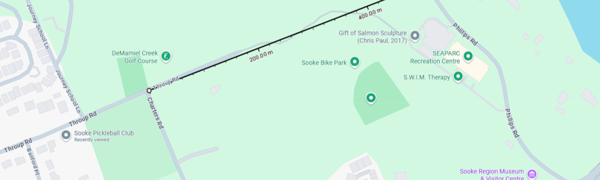
# Real Priority = Taking Action Now
For more than 30 years, multiple levels of government have been calling a connection from Throup to Phillips a "priority." Decades later that looks like a wish or a platitude, not a real priority. Over the last term, the District of Sooke has spent over $700,000 on engineering and preparatory estimates, alone, not even considering the staff and council hours that have been spent preparing and considering options. Meanwhile, the route has major challenges and the district doesn't even own the land yet. There has also been significant community opposition to the route, particularly for designs that involved impinging on the Art Morris ball fields.
Regardless of design specifics, the proposed connector has some long term negatives:
- More (and likely faster) traffic next to a school that is not already on the highway.
- More (and likely faster) traffic next to bike park, Art Morris ball fields, Skateboard Park, SEAPARC, and golf course.
- Interruption to wildlife corridor from ocean front to De Mamiel creek and the hills.
- Destruction of a small but well used hike/bike connection.
- Major impact to half a dozen homes and their residents.
- Moderate impact to all of Throup road with additional traffic.
There are also challenges to construction:
- Significant elevation changes
- Still need to purchase the land
- Major interruptions to traffic on Phillips Rd
With that laid out, what are the alternatives and how do they potentially compare?
- Drennan St to Golledge Ave:
- Pros
- Doesn't directly impact schools.
- Shorter.
- Slightly less expensive.
- Cons
- Would still impact Art Morris, impact SEAPARC even more and directly conflict with Museum/SeaPark entrance - largely equivalent in safety negatives.
- Still interrupts wildlife corridor but also directly impinges on the wetlands behind the museum.
- Would destroy a different hike/bike connection.
- Would dramatically impact a larger number of homes and their residents.
- Significantly less useable as an emergency exit from Sunriver.
- All connecting roads until you get to Charters are small, making it less practical.
- Pros
The math on that option really doesn't add up.
- Helgesen Rd to Sunriver Way at De Mamiel Dr?
- Pros
- Does run along the backside of elementary school but it's not an access road to the school.
- Wouldn't impact any sports facilities.
- Provides a better emergency exit for Sunriver.
- Cons
- Still interrupts wildlife corridor but also disrupts a salmon bearing stream.
- Would likely also destroy a just-built hiking connection.
- Would have a significant impact on a currently undersized road (Helgesen) and likely require buying and destroying several homes.
- Way worse elevation issues to deal with
- Significantly more expensive to implement.
- Pros
Again, the math doesn't add up.
- Pascoe Road to Sunriver Way or Phillips.
We can rule this out on on cost alone - it is not a feasible project for the District to take on.
# Other Options?
At this point in time, I don't believe we have any other options of a connector from Phillips/Sunriver to the rest of Sooke. If you believe there is another route that could work, I would love to hear about how it measures up to the pros and cons of the other options I've discussed here!
# Why Build It?
Will a Throup to Phillips connector "solve" our traffic problems? No, it won't - but it will have significant benefits:
- It will provide a second route out of Phillips Road - with the population of Sunriver, this is absolutely critical emergency infrastructure. It's only a first step in getting adequate emergency access but it's an important one.
- It will reduce traffic on Sooke Road - I suspect the reduction will be significantly more than the detractors suggest but a little less than the traffic study says is possible, simply because people are set in their ways.
Beyond these direct benefits, the Ministry of Transportation and Transit has informed Sooke staff and council that until we "fix our internal road connections," they consider the District to be responsible for all the traffic congestion and challenges of Highway 14 and will consequently be very reluctant to consider any new projects to improve the highway. If we want Provincial assistance and funding on Highway 14 infrastructure issues we really do need to show that we are doing what is in our power to improve traffic flow. Despite this information being presented to council, none of the current councillors could agree on a referendum to move the project ahead - or to stop spending money on "considering" it.
Quite simply we need to make a decision and we need to take action. Despite the challenges and negatives, I believe we need to proceed to build the Throup to Phillips connector.
# Next Steps
Every year that council has delayed taking action on this, the potential costs have increased. We've also missed out on several opportunities to reduce costs - holding a referendum to gauge actual community appetite at the same time as the current election would've saved approximately $50,000. As it is, we have to accept that further delays will only increase the costs involved.
I believe we should immediately proceed with the section named in planning documents as CP5 - specifically from Throup Road at Charters to Phillips Road. The improvements to Throup Road from Charters to Church will have to be in the future, given budgetary constraints. The improvements to Phillips Road will also have to be in the future.
What should the connector look like?
- Round-about at Phillips Road
- Connect to existing intersection at Charters/Throup.
- Mixed used trail divided from roadway on one side -- similar to how Wadams Way was initially developed.
- Wildlife tunnel - not just a small culvert - to ensure safe passage of wildlife under the road and reduce accidents
- 2 travel lanes, for now.
- Full width base.
How can we achieve these improvements?
- Stop dithering
- Buy the land. While I think it would have been much better to have held a referendum, this can be done without a referendum - a 2% tax increase for 5 years will be sufficient for the above plan.
- Finalize engineering plans with 2 lanes and single multi-use trail - like Wadams Way when it was first built.
- Hold a referendum on improvement options -- allowing the District to know and plan for how much grant money will be needed.
- Once we've shown we're working for it not just endlessly talking about it, the Province is much more likely to be willing to help us proceed.